Announcement

Collapse
No announcement yet.

Special Event Tuesday: CONNIE FLIGHTS - New York to Bermuda

Collapse
X
  •  
  • Time
  • Show
Clear All
new posts

  • Special Event Tuesday: CONNIE FLIGHTS - New York to Bermuda

    SPECIAL EVENT TUESDAYS GROUP FLIGHT:
    • Vintage Prop Airliner Series
    • Lockheed Constellation Inaugural Flight New York to Bermuda


    Here is an interesting comment I found several places on the internet that I would like to use as the focus of our first CONNIE group flight.

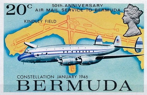
    "A civilian type certificate for the Constellation was awarded on December 11, 1945 and commercial operations were inaugurated by Pan American on February 3, 1946 between New York and Bermuda. TWA followed three days later with Constellation service on their New York to Paris route. "


    I have put together a flight plan for a direct New York to Bermuda flight. I previously posted important information about these group fights on the forum which I encourage you to read. The full post can be accessed by clicking on the link below.

    http://msflights.net/forum/showthread.php?1438-Proposed-SPECIAL-EVENT-TUESDAYS-GROUP-FLIGHTS

    Recently some of us have been flying an exceptional Lockheed Constellation from P3D, that comes without a GPS autopilot and requires a different set of skills to navigate effectively. I plan to add the first special event for next Tuesday, January 7, 2014 at 9 PM where we will fly this aircraft on its maiden flight from New York to Bermuda. We will be using both a little bit of dead reckoning with correction for cross winds and VOR radio navigation to find Bermuda out in the middle of the Atlantic Ocean. An ILS landings will be encouraged.


    For those who do not have this specific aircraft livery, they can also participate by downloading any freeware version of any aircraft that is appropriate to the specific group flight parameters. These are :

    1. Vintage autopilot based on VOR navigation (no GPS).
    2. Piston prop liners of the late 1940's or early 1950's of sufficient range and speed to keep up with the Connie


    -Coast
    "Having fun with friends! "

  • #2
    The flight plan is quite simple,

    DEPART
    : KJFK John F. Kennedy International
    ARRIVE: TXKF Bermuda International

    Fly a heading of approximately 150° for 662 nm. Since the range of the VOR at Bermuda (BDA 113.9 MHz) is 195 nm we will be out of its range for about 70% of the time, so we need to adjust for any crosswinds. Since the flight time is about 2hrs 30mins, we should expect to pick up the VOR about 1hr 45mins after departing KJFK.

    Once we are close enough to Bermuda to SEE the airport, we will fly SOUTH of the airport making LEFT traffic to land on Runway 30 (9706ft at elevation 9ft). The ILS for runway 30 is 109.9 MHz at 298°.


    A FSX flight plan is attached, but it really isn't that useful since we can't use a GPS.


    Finally the answer to question that always is asked, .... we will be flying between 19,000 ft and 20,000 ft give or take. The vintage autopilot doesn't allow for the same level of control as the newer GPS autopilot does, so you need to keep an eye on it and adjust it manually to maintain the intended altitude.

    -Coast

    PS:
    1. We will be departing KJFK on Runway 13R to minimize the turn needed for a bearing of 150°.

    2. To enhance the experience you might want to turn off the "gamer tags" to really get a feel of being on your own without a GPS, flying over the vast Atlantic ocean looking for a small one square mile rock of an island.

    3. The most important piece of equipment on the Lockheed Constellation that you will need to understand and use effectively is the vintage Sperry autopilot. I found a helpful description on how to use it for the FSX DC-3 at this web site. The Lockheed Constelation will require difference values than the DC-3, bur frankly I don't know them yet.


    Last edited by Coast; January 6, 2014, 02:38 AM.
    "Having fun with friends! "

    Comment


    • #3
      1. If we're going with VORs, then we also have the outbound VOR at KJFK (115.9Mhz, callsign JFK) which also has a range of 195 nmi. You could fly its outbound 148 radial and "bracket correct" for wind. That way, you're only flying out of VOR range for 40% of the time, rather than 70%.

      2. As a historical note, was the VOR system sufficiently deployed here for the start of 1946? If not, there's a medium-range NDB near the airport at Bermuda (323 kHz, callsign BSD, range 75 nmi) that can be used with deduced reckoning. Also I believe this era was pre-DME.

      3. Know of any good online wind-triangle utilities for people without an E6B or similar?

      4. Also I'm assuming that we should fly the 049 Connie, not the 749 (which has an easier to use autopilot), as the latter was introduced in April 1947, a year after the flight we're commemorating. What do you think?

      This will be fun. Thank you Coast.

      Comment


      • #4
        Originally posted by Storm View Post
        1. If we're going with VORs, then we also have the outbound VOR at KJFK (115.9Mhz, callsign JFK) which also has a range of 195 nmi. You could fly its outbound 148 radial and "bracket correct" for wind. That way, you're only flying out of VOR range for 40% of the time, rather than 70%.

        2. As a historical note, was the VOR system sufficiently deployed here for the start of 1946? If not, there's a medium-range NDB near the airport at Bermuda (323 kHz, callsign BSD, range 75 nmi) that can be used with deduced reckoning. Also I believe this era was pre-DME.

        3. Know of any good online wind-triangle utilities for people without an E6B or similar?

        4. Also I'm assuming that we should fly the 049 Connie, not the 749 (which has an easier to use autopilot), as the latter was introduced in April 1947, a year after the flight we're commemorating. What do you think?

        This will be fun. Thank you Coast.
        As of 1946, VOR became the standard navigation system for the united states airspace system, however NDB was still a far more popular option due to its cheap cost and familiarity to pilots at the time. This particular route was originally flown using NDB because at the time the Bahamas did not have an airspace system. So pilots used the local AM radio stations to fly to the islands. Even in 1946 the us airspace system was still in its childhood. It wasn't untill 1956 that sweeping changed happened to force VOR to become a required item on the aircraft. This was because of the http://en.m.wikipedia.org/wiki/1956_...-air_collision

        I also want to ad that alot of flights over the water where don't at night because they used celestial navigation, which allowed them to navigate by the stars which is how alot of nautical terminology was picked up in aviation.

        for an E6B substitute I would recommend something free on your smart phone, I use E6B gizmo on windows phone and I use Garmin pilots built in E6B on android.
        http://www.studentflyingclub.com/flight-planning.php
        I would check that out and see if it fits your need.

        your also talk about flying away from the station. Don't do that, find an e6b or something like it and find your wind correction angle, that way you fly direct to the station. The autopilot should do this on its own, if not use the heading select (if you have it) and fly on at set heading,tracking the station.

        Comment


        • #5
          The webpage is useful, thank you. (I don't/won't be using a smartphone app, having no need for a data-enabled smartphone.)

          Why not fly outbound on a VOR radial? It's not as though it's an NDB! Why would that not work for the first 30% of the flight? You can still calculate wind correction, as you'll need that for the middle 40% of the flight. You can fly inbound to the final VOR on the final 30%.

          Outbound radial tracking by hand, with bracketing, is standard practice and even easier and effective to do with the help of a crude autopilot. Why not do it that way? Besides you have to assume that the autopilot is so crude, it will only hold your set heading and set pitch and not track you to or from a navaid automatically.

          Comment


          • #6
            I posted some screenshots in the forum at

            http://msflights.net/forum/showthrea...ork-to-Bermuda

            -Coast
            "Having fun with friends! "

            Comment

            Sorry, you are not authorized to view this page
            Who has read this thread:
            Working...
            X